Cerro San Lorenzo part 6 - descent and route 40 home
The next morning (June 20) we woke up to lenticular clouds and a beautiful halo around the sun. Looked like bad weather was coming our way and we thus packed our stuff to begin our descent. Also we were running out of food, gas and time which made the choice easy.
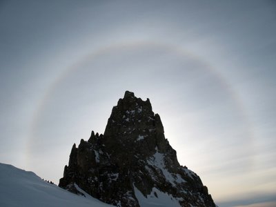 The halo around the sun
[photo by Carlos Buhler].
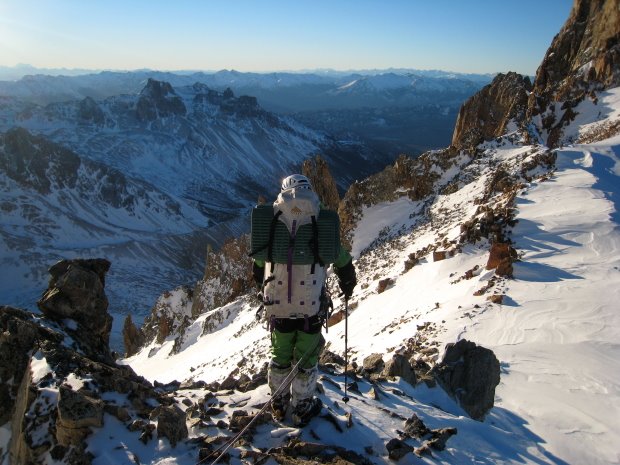
As mentioned in part 4 it would not be fun to descent the frozen ravine that we ascended from the Rio Oro valley and we thus decided to descent into Chile although we didn't know what we would meet that way. That also made that descent route more interesting and we thus walked North from the Camp 1 plateau over a ridge and descended into a gully.
 Carlos at the ridge North of Camp 1 where we descended into Chile.
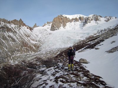
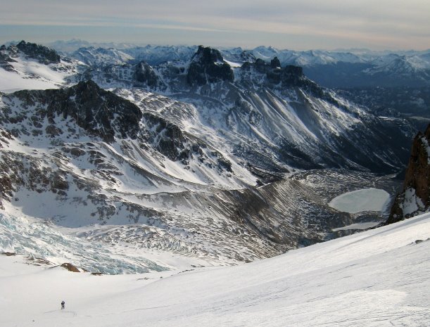
The gully soon changed into a snowfield with packed snow - wished we´d had those conditions the day before yesterday on our approach to our intended route! At this point we also noted a big lake which I remembered from an internet photo - we were on the right way as the Refugio Toni Rohrer (a.k.a. the Agostini hut) would be just North of the lake in the forest!
 Carlos descending the snowfield. Note the big lake. The Refugio Toni Rohrer is located in the forest behind the lake left of the river.
We stayed on the snowfield until we reached the flat part of the glacier seen on the right on the picture above. The conditions were perfect and only once did we have to rappel to get down two steep steps.
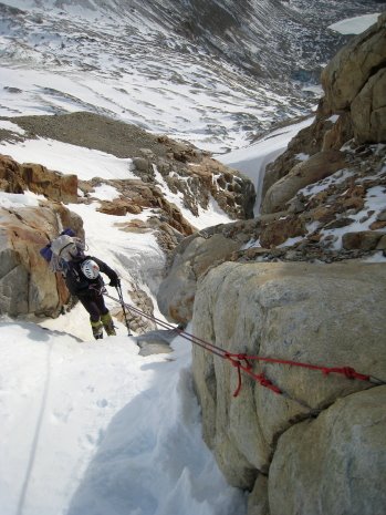
 Carlos rappelling the steep steps.
Eventually we crossed the glacier to get to the left side of the lake as the right side looked steep and exposed to rock fall. Also, we were convinced that we would find the path of the normal route on that side of the lake (which we did).
 A look back at our descent route from the col on the left. Initially we descended the rocky snowfield until we were forced onto the lower part of the glacier at which point we crossed it. We then descended the moraine (as seen here) until we joined the path of the normal route marked by cairns.
On the left side of the lake we followed the moraine until we found the path of the normal route which was marked with cairns. The path led us to the Toni Rohrer hut which we checked out but decided not to use - it was not particularly cosy and we had to pay to stay there which would be a hassle.
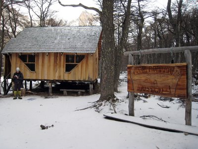 The Toni Rohrer hut (a.k.a. The Agostini hut) - the base camp of the normal route.
The hut can be reached by horse and there was thus a nice trail out of the valley which we hiked until it got dark. Sat up camp in the forest and the next morning we hiked the last bit to Puesto Muñoz.
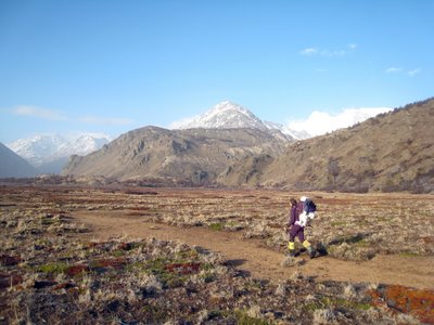 Carlos hiking the last bit back to Puesto Muñoz.
We had a last lunch with the cowboys and then drove of - we had to catch our airplanes in Buenos Aires (2500 km away) in three days! Instead of driving the same way "home" via the ocean route 3, we decided to drive North via Routa 40 following the Andes mountain chain. It was a much more beautiful drive which I can highly recommend. In particular the town El Bolsen and the Rio Negro area was extremely beautiful, where Bariloche was a overrated dump with ugly slum ghettos (at least the parts we were driving through).
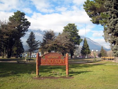 The beautiful hippie town El Bolsen with its motto "Zona No Nuclear"!

The lake in the center of El Bolsen.

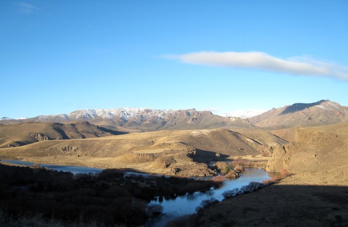
 The beautiful Rio Negro area.
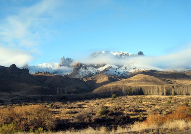
Mountains of the Rio Negro area.
Final reflexions:
Back in Denmark a month later it is time to reflect on the trip. Obviously we did not reach our primary goal of a new route on the East faces of Cerro San Lorenzo, but yet I would not call the trip a failure. We found a new approach to the mountain, made the first ascent of a rock tower, saw the beautiful landscapes of Argentina (all together we drove 6500 km!), and had a great time with all the people we met on our way.
The mountain has a huge potential for new routes on the East, South and North-East faces and there are plenty of rock towers waiting for their first ascent. You will have to work a lot harder for these first ascents than doing an alpine climb in e.g. Chamonix, but you will for sure have a much greater adventure!
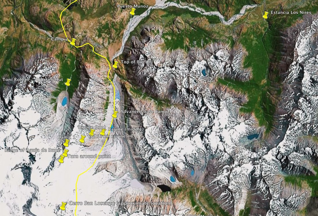
GPS coordinates
Oh, and then just one last thing: a map of the area with our place marks. Click here to download a Google Earth file with our GPS coordinates (krz file format which you need the free program to open).
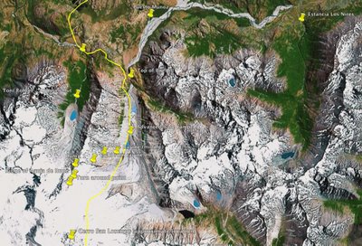 Google Earth map with our place marks.
Read the previous parts of the story:
Part 1: Cerro San Lorenzo - getting there.
Part 2: Cerro San Lorenzo - advanced base camp.
Part 3: Cerro San Lorenzo - life at Puesto Muñoz.
Part 4: Cerro San Lorenzo - attempt on Cerro San Lorenzo.
Part 5: Cerro San Lorenzo - ascent of Aguja de Rune.
Previous posts.
Or go to my homepage to read other climbing stories: www.climb.dk
 The halo around the sun
[photo by Carlos Buhler].
As mentioned in part 4 it would not be fun to descent the frozen ravine that we ascended from the Rio Oro valley and we thus decided to descent into Chile although we didn't know what we would meet that way. That also made that descent route more interesting and we thus walked North from the Camp 1 plateau over a ridge and descended into a gully.
 Carlos at the ridge North of Camp 1 where we descended into Chile.
The gully soon changed into a snowfield with packed snow - wished we´d had those conditions the day before yesterday on our approach to our intended route! At this point we also noted a big lake which I remembered from an internet photo - we were on the right way as the Refugio Toni Rohrer (a.k.a. the Agostini hut) would be just North of the lake in the forest!
 Carlos descending the snowfield. Note the big lake. The Refugio Toni Rohrer is located in the forest behind the lake left of the river.
 We stayed on the snowfield until we reached the flat part of the glacier seen on the right on the picture above. The conditions were perfect and only once did we have to rappel to get down two steep steps.
 Carlos rappelling the steep steps.
Eventually we crossed the glacier to get to the left side of the lake as the right side looked steep and exposed to rock fall. Also, we were convinced that we would find the path of the normal route on that side of the lake (which we did).
 A look back at our descent route from the col on the left. Initially we descended the rocky snowfield until we were forced onto the lower part of the glacier at which point we crossed it. We then descended the moraine (as seen here) until we joined the path of the normal route marked by cairns.
On the left side of the lake we followed the moraine until we found the path of the normal route which was marked with cairns. The path led us to the Toni Rohrer hut which we checked out but decided not to use - it was not particularly cosy and we had to pay to stay there which would be a hassle.
 The Toni Rohrer hut (a.k.a. The Agostini hut) - the base camp of the normal route.
The hut can be reached by horse and there was thus a nice trail out of the valley which we hiked until it got dark. Sat up camp in the forest and the next morning we hiked the last bit to Puesto Muñoz.
 Carlos hiking the last bit back to Puesto Muñoz.
We had a last lunch with the cowboys and then drove of - we had to catch our airplanes in Buenos Aires (2500 km away) in three days! Instead of driving the same way "home" via the ocean route 3, we decided to drive North via Routa 40 following the Andes mountain chain. It was a much more beautiful drive which I can highly recommend. In particular the town El Bolsen and the Rio Negro area was extremely beautiful, where Bariloche was a overrated dump with ugly slum ghettos (at least the parts we were driving through).
 The beautiful hippie town El Bolsen with its motto "Zona No Nuclear"!
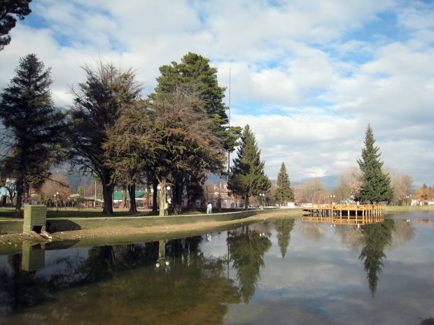
The lake in the center of El Bolsen.
 The beautiful Rio Negro area.
Mountains of the Rio Negro area.
Final reflexions:
Back in Denmark a month later it is time to reflect on the trip. Obviously we did not reach our primary goal of a new route on the East faces of Cerro San Lorenzo, but yet I would not call the trip a failure. We found a new approach to the mountain, made the first ascent of a rock tower, saw the beautiful landscapes of Argentina (all together we drove 6500 km!), and had a great time with all the people we met on our way.
The mountain has a huge potential for new routes on the East, South and North-East faces and there are plenty of rock towers waiting for their first ascent. You will have to work a lot harder for these first ascents than doing an alpine climb in e.g. Chamonix, but you will for sure have a much greater adventure!
GPS coordinates
Oh, and then just one last thing: a map of the area with our place marks. Click here to download a Google Earth file with our GPS coordinates (krz file format which you need the free program to open).
 Google Earth map with our place marks.
Read the previous parts of the story:
Part 1: Cerro San Lorenzo - getting there.
Part 2: Cerro San Lorenzo - advanced base camp.
Part 3: Cerro San Lorenzo - life at Puesto Muñoz.
Part 4: Cerro San Lorenzo - attempt on Cerro San Lorenzo.
Part 5: Cerro San Lorenzo - ascent of Aguja de Rune.
Previous posts.
Or go to my homepage to read other climbing stories: www.climb.dk
Labels: climbing
posted by Hans Bräuner-Osborne at
17:02
![]()
 blog updates
3 Comments:
Hans, I really enjoyed your entire travelogue and photos and videos of Cerro San Lorenzo. I was in a group that attempted to summit San Lorenzo back in 1993 (?)from the Chilean side, but we ran into a few days of snow, and ran low on gas to melt water, and had to turn back. The only photo I have from that trip online is here:
http://photo.net/photodb/photo?photo_id=161503&size=lg
I do hope to go back someday. I may or may not attempt the summit again but I do want to see how the 11th Region has changed since I was there 15 years ago.
Sincerely,
Gen Kanai
http://kanai.net/weblog/
Hello Hans,
thanks a lot for this detailed trip report - very useful for our current trip planning =)
Hope you don't mind if I gonna ask you some additional questions in near future.
Hasta luego, god jul og godt nytt år!
Frank
Hola Hans, great "relato". Hope soon you will be back to San Lorenzo area. Count on us for any help you need. All the best
Rafa
Estancia Menelik
rsmart@cielospatagonicos.com
Post a Comment
Subscribe to Post Comments [Atom]
<< Home